




NGO: Map shows extent of Baram dam's devastation
A Swiss based NGO has released what they call a “secret map” that paints the picture of the environmental devastation that the proposed Baram dam in Sarawak will cause.
A Swiss based NGO has released what they call a “secret map” that paints the picture of the environmental devastation that the proposed Baram dam in Sarawak will cause.
"According to the map based on intelligence and calculations by the Bruno Manser Fund (BMF), the 162 meter high Baram dam would flood a rainforest area of 412 square km (41,200 hectares) and at least 26 indigenous villages, causing the displacement of up to 20,000 Sarawak natives...
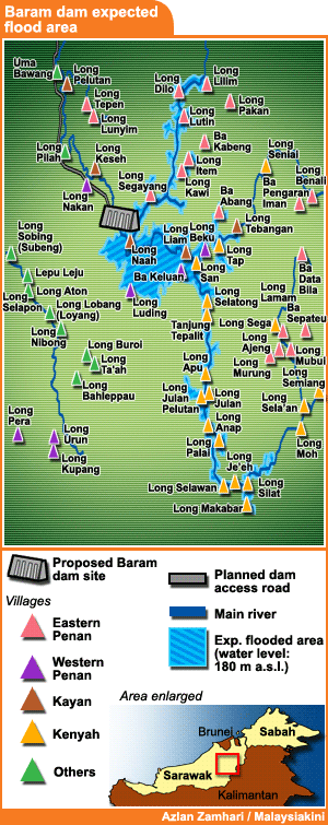 “While the Sarawak government has started legal procedures to extinguish native rights for an access road to the dam site, the affected communities are deliberately being kept in the dark over the extent of the dam plans,” read BMF’s statement yesterday.
The NGO at the forefront of championing environmental and native rights issues in the Borneo state listed the 26 villages that it says will be drowned out by the dam when it is completed.
“The proposed dam would cause havoc for the Kenyah, Kayan and Penan culture in the upper reaches of the Baram river, one of Borneo's great rainforest streams.
“Many of their villages would be submerged and would literally cease to exist.
“Traditional longhouse communities in the dam's downstream areas would also have to face drastic changes and pollution of the riverine ecosystem, affecting river transport, fishery, irrigation and access to drinking water,” said BMF.
The villages affected downstream, it said, include the regional centers of Marudi and Long Lama as well as the villages and longhouse of Long Keseh, Long Pila, Long Laput, Kejaman, Long Pelutan, Uma Bawang.
'No official map to date'
BMF rep Lukas Straumann when contacted explained that the map was drawn based on calculations and topographic data held by BMF, not an official government map.
“However, the 180 metre above sea level quota and the height of the dam wall are drawn from official statements,” said Straumann.
 “We call it a ‘secret’ map as it is 100 percent certain that the state government and Sarawak Energy have drawn detailed maps of the flood area but are deliberately withholding them in order to deceive the affected communities and stifle possible protests.
“No one has ever seen or been shown a flood area map by Sarawak Energy or the state government,” he added.
BMF called on the state government to halt the project and “immediately release all official studies on the planned Baram dam”.
 The contentious dam is one of 12
gigantic hydro-electric dams
- not counting the controversial Bakun dam - planned across the state as part of Chief Minister Abdul Taib Mahmud’s grand plan for the state’s Sarawak Corridor of Renewable Energy (Score).
The contentious dam is one of 12
gigantic hydro-electric dams
- not counting the controversial Bakun dam - planned across the state as part of Chief Minister Abdul Taib Mahmud’s grand plan for the state’s Sarawak Corridor of Renewable Energy (Score).
The estimated cost is RM36 billion but critics expect budget over-runs, such as those that have afflicted Bakun.
Opponents to the Baram dam, such as Orang Ulu National Association’s chairperson Peter NJ Kallang, say the proposed resettlement will destroy the indigenous Sarawakians’ way of life.


Are you sure you want to delete this comment?
This action cannot be undone.